Purple Columbine

More Flower Pictures


Heceta Head, Oregon

More Lighthouse Pictures

Updates


Home   Screensavers   Logic Puzzle   Information/FAQ   Contact Us


Click here to sign up to receive updates by email


(click thumbnail images to see larger pictures)


Quicksand & Mission Impassable (when wet)


April 9, 2008

Older Updates

July 3, 2007

May 23, 2007

Sept 28, 2006


The sign said "Road Closed to Thru Traffic"...  At least I think that's what it said, it went by pretty quickly.

It was the "scenic route" between Page, AZ and Las Vegas, NV.  I realized after a short time that I might have a book describing hikes in this area so pulled over to take a look.  The book describes a "walk-in, photogenic slot canyon", 2 miles north on this paved road then 21 miles NE on dirt.  30 minutes there, hike it and still be in Vegas before dark.  Nope.  

It was Tuesday, March 25.  I left KC the first week in March to begin traveling though the southwest after finishing a long term IT project in February.

The road turned into a muddy milkshake at higher elevation when the shade of pine trees and lingering snow melt made it a complete mess.  It's not the kind of gravel country road you find around KS.  It's a fine dirt/clay that gets REALLY slippery when it gets wet.  Not a good time to find out the traction control on your new car will get you stranded as it kills power to the wheels (note:  you cannot shut off traction control on Toyota Highlander Hybrids). 

I saw the wet section ahead and sped up a little to get through it.  The roads are graded with a higher center so the water drains to the sides where there's usually a small ditch before a mound of dirt.  I started sliding toward the side and the car started slowing down even as I floored it.  Slower and slower, sliding more and more toward the ditch.   "We're going to get stuck"   The car stopped.  I don't even know if I can open the door as driver's wheels are in the ditch and we're pushed up against the dirt mound.  Rocking back and forth between Drive and Reverse over the course of some minutes we pulled out and ahead to a firm spot in the road; the ruts visible behind.   No hiking in the agenda...  we're going back.  The road appears to just get worse ahead; but now we have to go back through that spot.  Full speed ahead.  The road dips right at the muddy spot and then goes up hill.  We start sliding and slowing down.  "POS!"  The tires start grabbing and we get through.  Whew?!?

Breathing a sigh of relief, we head back.  We crest the last hill before the paved road and see a white Explorer with a large green stripe on the side and letters that read "Sheriff".  ;-)  We pass next to each other as I give him the finger (wave) and he flips on his lights and stops.  I just knew he was going to ask "did you see that Road Closed sign?"  and I'd have to say "Yes" and come up with some explanation that we weren't "thru trafffic"; but rather a "go to the hike and come back" type of traffic.   I actually thought maybe a bridge was out a few miles down and we might have to turn around before the trailhead.  In any case, not a big deal if we make it to the trailhead or not... let's try.


The sheriff rolls down his window and asks if we saw anyone back where we came from.  He's been called out to rescue a deputy stuck in the mud up the road.  We didn't go far enough apparently.  "No, didn't see anyone.  We turned around when it got too muddy."  We exchange pleasantries and go on our way.

I would have to stop later and chip dried clay off the wheels with my pocket knife because it was throwing them out of balance.

I was researching how to shut off the traction control when I got back.  You can't.  Others discuss this "feature" in a sometimes humorous discussion on a site:  "experience felt like running out of gas, no reponse to pushing on the gas pedal, car became a boat anchor".   This is consistent with my experience.    http://tinyurl.com/5b3zed

Apparently the vehicle is good at getting you stuck in mud, deep snow, sand and other situations you might think of where you need to maintain momentum through a spot.

From another web site:  Toyota insists the system works as intended, and spokesman Bill Kwon believes without it, drivers would still be stuck. "A vehicle without TRAC in those conditions," Kwon said. "would probably just start spinning in place and eventually spin out of control. In my opinion, it's better to have the vehicle stop then to have the wheels spinning and out of control."
I'll take Kwon for a ride sometime and see if he still thinks that (in his car of course)  ;-)

Note:  I like my car; but now know it's limitations.

Vegas was a fun change of pace but I would soon be headed on the most notable adventure of the trip: a four-day, 38 mile backpacking trip through Paria Canyon.  Wow!!

A satellite image map of the hike can be seen here (you can zoom in on parts):  http://tinyurl.com/6xyc85

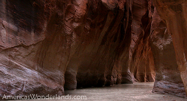
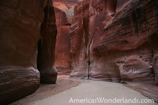
I started at the White House trailhead.

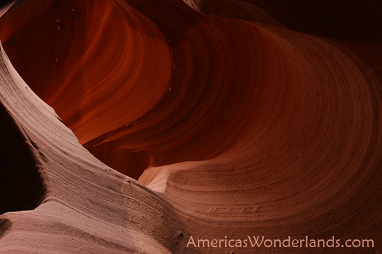
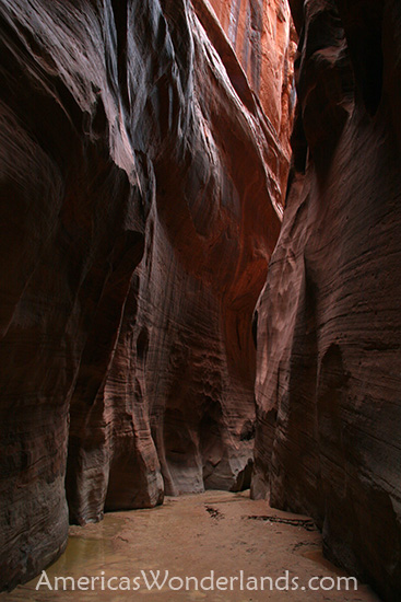
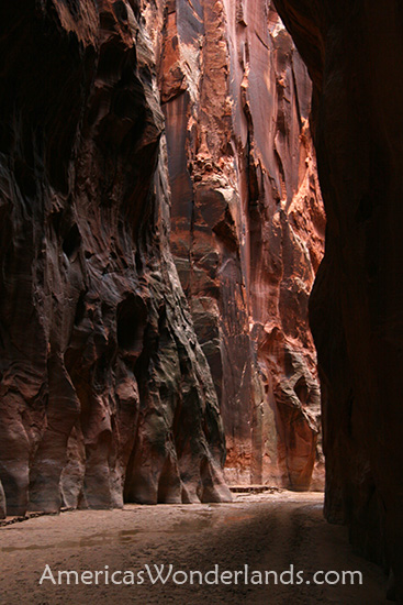
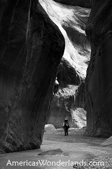
The Paria Canyon and it's most notable tributary Buckskin Gulch (the longest slot canyon in the world) are considered by many to be one of the finest backpacking trips in the US.   I agree. 

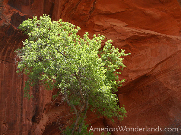
The hike is a photogenic thrill ride with mesmerizing scenes around every corner and sufficient solitude (in the lower part) to make it a true wilderness experience.

I saw a number of people on the first day, 5 or 6 on the 2nd day then nobody after 6pm on day 2 until the trailhead at 7pm on day 4.   49 hours of no contact.  I still spoke occasionally though...  mostly swear words like  "#$%@ing Quicksand!!"   ;-)

I had read trail descriptions, trip reports and talked with the rangers before staring the hike and saw occasional statements like "watch for quicksand after a flood".  One source reported that quicksand was rare and more of a remote possibility than something to worry about. 

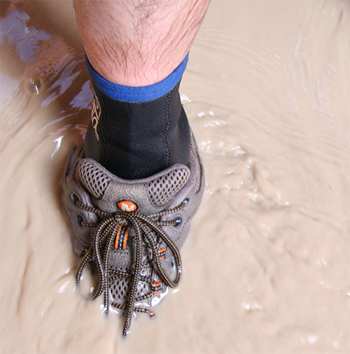
Quicksand has a rubbery firm top layer and will support you briefly before collapsing.   I learned how to feel it out with my hiking poles after going down fast.   I sank immediately up to my shins, then went down onto my knees in the river which was now waist deep (surprise!!).   Trying to keep my camera dry and avoid sinking further, I was able to crawl/shuffle my way out but not without first dunking my ipod (still works), and pockets full of snacks and maps.

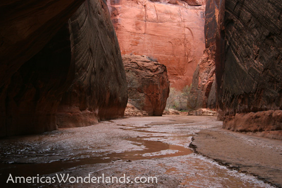
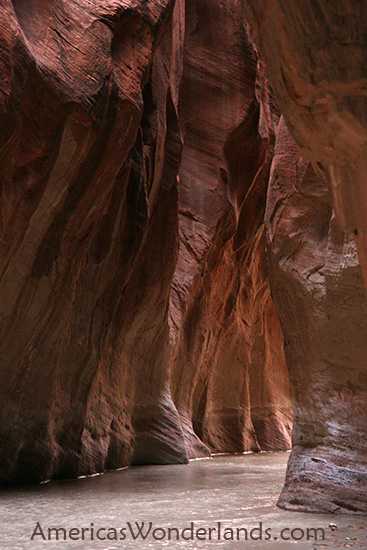
The hiking was slower from that point forward as I probed each step in the river which was muddy so you couldn't see the bottom. (see photo).  There was quite a bit of quicksand.   On some sandy areas before crossings hikers scrolled with hiking poles "Quicksand --->"  or "DEEP! -->"...  that was nice.  I met a guy named Ryan from Minneapolis/St Paul on the first day and briefly on the 2nd who was traveling the same way and was ahead of me.  Cool guy was a photographer for a paper in the area and wants to do freelance photography full time.

Hiking was frequently in the river with countless crossings and several stretches where the hiking was just easier in the river.  (wear pants... the backs of my legs were very scratched up from bushwhacking in shorts).

The canyon was amazing and easily one of the best hikes I've ever done.   Drinking water was a bit of an issue as the river water was too muddy to be drinkable so you had to watch for springs marked on the map.  The biggest stretches were on the first and last days.


One of the side trips up Wrather Canyon was to the 4th largest natural span in the word with a span of 246 feet.   It was very cool although the photos turned out "just ok".
http://www.naturalarches.org/big9.htm

The only downside to the trip was at the end where a note on my car said "call your mom, family emergency".   The note was place 3/28, the same day I entered the canyon.  I received the note on 3/31.  My grandfather Wilbur Widick passed away at the age of 91.  He liked to camp and fish and I liked going with him.   I was able to make it home for the funeral.

A couple of notable quotes from the text message archive:
* when driving 54 between Guymon, OK and Liberal, KS at night:  "There's definitely more cows than people out here...  just passed the biggest feedlot I've ever smelled."  Note:  There was a story in the paper yesterday about a proposed biodiesel plant in Guymon, OK to produce 31 million gallons of fuel annually from pork fat...  blech??!  That's a lot of bacon.    http://www.kansascity.com/business/story/565400.html

* Arriving in Liberal, KS:  "If Kansas had canyons like the Paria, I bet they would be 'Toto-lly Awesome'.  I'm in Liberal... home of Dorothy's house."  

Lastly, when passing through Greensburg, KS - the town devastated by a tornado recently there's a sign that reads "We Will Rebuild" with a big Calvin peeing on a twister...  hilarious.

Other notes: 
- I'm back in KC now and celebrated a big birthday on Sunday
- My brother gets married this weekend so looking forward it
- I will shortly be actively seeking a new IT gig so let me know if anything comes up

Photo Descriptions:

Buckskin Series:  Buckskin Gulch is the longest slot canyon in the word.  Hikers choosing to start at the Wire Pass trailhead get to see more of it; but its a 14.5 mile hike to first drinking water which is a really long day over that terrain.   I started at the White House trail head and hiked up Buckskin 1.5 miles from the confluence then back out (see map link above).

Desert Poppies: 
I'm driving along and see a couple flowers, then a few more, then a blotch of color on a distant hill, then massive hillsides completely covered in desert poppies.  AMAZING!  

Canyon Shots:  Most are of the Paria & Buckskin although one is from another slot canyon near Page.

I hope this note finds you all doing exceedingly well.  Drop me a note when you get a chance and let me know how things are going.

Best Regards,
Kevin


AmericasWonderlands.com

Copyright 2008 K. Venator