|
|
Welcome to the AmericasWonderlands.com guide to exploring New Mexico's Gila Wilderness & vicinity. Content is divided into the following sections as described by their respective headings: Introduction, Logistics, Activities & Attractions, Hiking Trails, Notes, Camping and Trip Planning Resources.
|
Featured Reading |
|
This is one of the 2 books I used to plan my hikes in the area. Frankly, if you want to do some hiking in the Gila, you should get it.
|
|
|
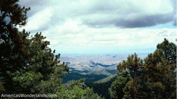
The Gila Wilderness Area in southwest New Mexico was the first dedicated wilderness areas in the country. Established in 1924, it is also one of the largest wilderness areas in the southwest at 557,873 acres (843 miles of hiking trails). The adjacent Aldo Leopold Wilderness area adds another 202,016 acres (191 miles of hiking trails). A third bordering area, the Blue Range Wilderness and Primitive Area adds another 222,500 acres (41 miles of trails).
This site provides a representative sample of available hiking options and other activities as well as a list of available resources for planning your trip.
The Gila and Aldo Leopold Wilderness Areas areas are located within the larger Gila National Forest in southwest New Mexico. The Apache National Forest, just across the state line in Arizona, borders the Gila National Forest and contains the Blue Range Wilderness.
Silver City, NM is centrally located within the Gila National Forest. Nearest major cities include El Paso, TX (157 miles), Tucson, AZ (200 miles), Phoenix, AZ (314 miles) and Albuquerque, NM (235 miles). The most likely approach from the east is available from I-25 and from the south via I-10. Routes from the west and north are available but will require reviewing a map to determine the best route depending on your destination.
Show overview map of the area.
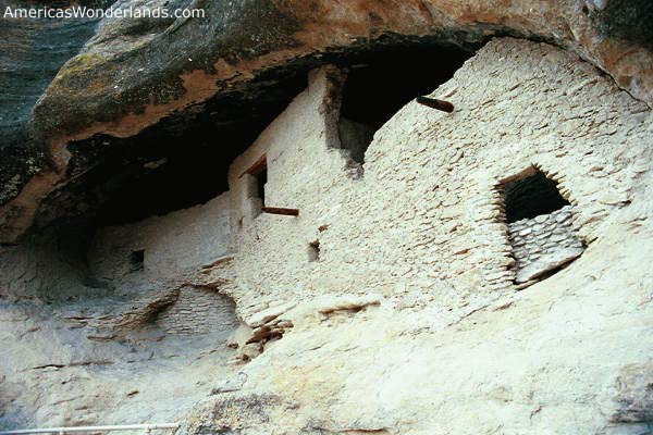
The Gila Cliff Dwellings National Monument, near Silver City, is the areas primary attraction and worth a visit. Activities in this area include seeing the cliff dwellings, hiking & fishing.
The Catwalk, near Glenwood, is another popular destination. A visit to The Catwalk is basically a hike up the river on a suspended platform through a small slot canyon. The structure was originally used by area miners long ago. Fishermen and hikers often use this area as the starting point for day hikes or extended adventures.
There are over 1000 miles of hiking trails between the three wilderness areas. There's a lot to choose from and you'll probably need help deciding (see section below and also Books & Maps).
This site covers only a representative sampling of the available hiking options (most within the Gila Wilderness Area).
Gila National Forest and Gila Wilderness Hiking Trails
|
|
|
|
Gila Cliff Dwellings National Monument North of Silver City via Highway 15. A few miles north of the Gila Cliff Dwellings Visitor Center at the end of the road. Short hike to see the cliff dwellings. An online topographic map of the Gila Cliff Dwelling area is available here. |
|
|
Little Bear Canyon
Near the Cliff Dwellings (8 miles, round trip, out and back). Obtain a map at the visitor center or via the purchase link below. The trail is referenced as #729. Park at the TJ Corral parking area just north of the Gila Cliff Dwellings visitor center on the east side of the road.
Hike through an interesting, modest slot canyon to the scenic Middle Fork.
|
|
|
Little Bear Canyon/Middle Fork Loop
Near the Cliff Dwellings (11 mile loop, last mile over the road to your car). Park at the TJ Corral parking area just north of the Gila Cliff Dwellings Visitor Center on the east side of the road. Obtain a map at the visitor center or via the purchase link below. Numerous water crossings.
Same as above, return via the scenic Middle Fork (possibly extend the trip to Jordan Spring). I enjoyed this hike.
|
|
|
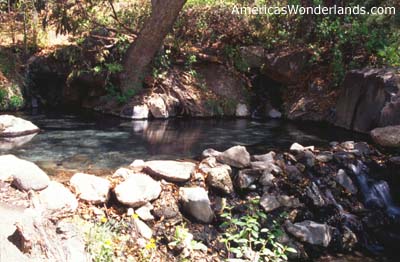
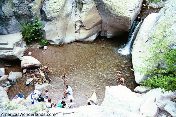
Little Bear Canyon to Middle Fork to Jordan Spring
Near the Cliff Dwellings. (12 mile - out and back via Little Bear Canyon). Obtain a map at the visitor center or via the purchase link below. Jordan Spring is out of sight on the right side of the river if you're hiking upstream. Watch for water flow coming from the right (east) bank approx 2 miles north of the Little Bear / Middle Fork junction. Rangers at the visitor center can mark your map with the exact location of the spring. This hike involves numerous Water Crossings.
Hike up the scenic Middle Fork to the hot tub like hot springs. Very nice. You can also hike up the Middle Fork from the parking area just past the cliff dwellings visitor center; but it's a longer route and you'll miss Little Bear Canyon.
|
|
|
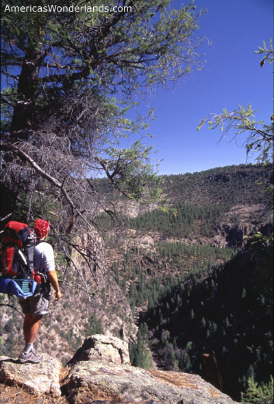
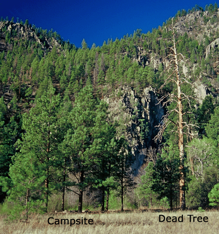
Middle Fork to The Meadows (multiple routes available including: straight up the Middle Fork via Little Bear Canyon then up the Middle Fork via Big Bear Canyon most of the way, return via the Middle Fork (25 miles))
Near the Cliff Dwellings. Route distance varies but it's a good 2-3+ day trip. Start at the backcountry parking area just past the visitor center or park at the TJ Corral trailhead (depending on where you want to start). Don't forget to stop at Jordan Spring (see above). The Meadows is an open area and a popular overnight spot.
This hike involves numerous water crossings. I met 3 people who were hiking up the Middle Fork in their quest to hike the Continental Divide Trail. Apparently, it's just off The Divide; but a more scenic route. They were hiking all the way to Snow Lake before catching back up with the trail to continue north.
Note: the picture is of my camp site in The Meadows. I used this photo as an illustration for a logic puzzle which is why it's labeled.
Another loop option would be to park at the TJ Corral and hike the Little Bear Canyon Trail (#729) to the junction with trail #164 to the Meadows. Return via the Middle Fork and the Little Bear Canyon. You can obtain maps and advice at the Gila Cliff Dwellings visitor center and also check the availability of water along trail 164. You can also order maps from the National Forest Service (see below). This loop is approx 25 miles.
|
|
|
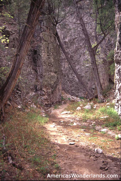
West Fork to Middle Fork via Prior Cabin
Extended backcountry 4-5+ day (40 mile) scenic river canyon trip, solitude and fishing with options to explore side canyons.
Near the Cliff Dwellings. Park at the Gila Cliff Dwellings Parking Lot and head up the West Fork trail. Obtain the Gila Wilderness topographic map at the visitor center or via the purchase link below.
I did this hike in April and really enjoyed it. Please allow me to reflect a little so you know what to expect. Hiking in the wilderness is much different from my past experience in the big national parks. It's not about climbing a mountain or hiking through a canyon (e.g. goal-oriented), it's more about taking it slow and enjoying yourself. I was able to catch fish using fishing line and a hook tied to my hiking pole with flies that I swatted with my hat (cool!). There was a stretch of 45 hours where I didn't see or hear another person. The wind still blows, the trees still sway and the snakes will still rattle if you get too close! ;-)
A few advisory notes: check with the rangers about the availability of water up high. On this route, there was water in Woodland Park (pond) and at Prior Cabin (stagnant - still ok; but clogged up my filter). There's also water collection structures at Prior Cabin so you'll want to check these if you're having trouble finding water. The signage along the trail didn't seem to match up very well with my map. From Hells Hole, I intended to go left, then up the Prior Creek trail to Prior Cabin. I ended up going through Woodland Park by mistake. While on the way to Woodland Park, I lost the trail briefly but was able to find it again by backtracking and following blazes cut into the trees. Also, I intended to descend from Prior Cabin via Garcia Spring. I didn't ever see Garcia Spring so you might want to confirm it's location if you plan to include it as a stop. Lastly, the trails are a bit confusing in the vicinity of Prior Cabin. If you stand on the front porch of the cabin and walk down the trail to the right (just past the water collection structures), the trail forks. The right fork continues down the drainage (I believe it's an unofficial, social trail; but not sure) while the left fork heads up and over a rise before continuing. The left fork of this trail took me back to the Middle Fork. (fyi, I used a 1997 version of the topo map - a newer version is now available). Be sure to take note of the canyons you pass when hiking the river as this will be about the only way you'll be able to judge progress (water crossings aren't marked reliably on the map).
This hike involves numerous water crossings.
Have fun!
|
|
|
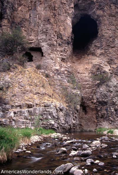
West Fork to Hells Hole
Near the Cliff Dwellings. Park in the Cliff Dwellings Parking lot and hike up the river.
2-3 day backcountry (approx 30 miles, out and back). Extend by crossing over to the Middle Fork via Prior Cabin (see above). Scenic river canyon, nice fishing & cliff dwelling with options to explore side canyons.
This hike involves numerous water crossings.
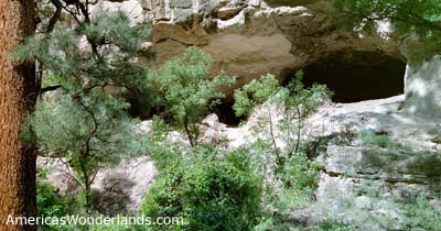
note to the curious (like me): it's a fairly hazardous scramble into the cave on the right and there's nothing in there except bat guano. ;-)
|
|
|
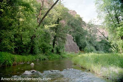
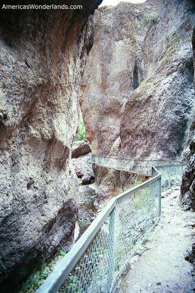
The Catwalk and Whitewater Creek
NE of Glenwood at the end of highway 174. The hike to the Catwalk is a 2 mile round trip although extending the hike up Whitewater Creek can be rewarding.
Interesting hike through modest slot canyon on suspended platform. Hike up the river a little further to swimming holes and fishing. Extended backcountry trips can also begin from here.
Topographic Map (note: Glenwood is off the map to the south). |
|
no pix from this hike. |
EE Canyon Loop Near the Cliff Dwellings. Park at Woody's Corral Trailhead. As referenced on the Gila Wilderness topo map, the loop is comprised of trail 160 to 162 to the EE Canyon trail returning via the West Fork and the Cliff Dwellings parking area. 8.3 mile day hike loop. I didn't enjoy this one as much as other hikes in the area. |
|
|
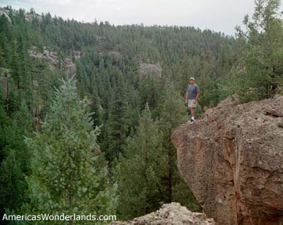
Caves Trail
Park at the Rocky Canyon Campground (between the Gila and Aldo Leopold Wilderness Areas). Locate it on the Gila National Forest map between Silver City and Emery Pass (NE of Lake Roberts on a primitive road).
4WD or high clearance vehicle required. Short interesting hike with good views and plenty to explore. The hike is about 2 miles, out and back plus whatever additional exploring you do in the area.
The top photo was taken after scrambling up above the caves (see photo 2) and continuing a bit further. Use caution if deciding to climb.
Topographic map (note: shows road to Rocky Canyon campground along the continental divide. Access via highway 35 between the Mimbres Ranger station and Lake Roberts). |
|
|
Hillsboro Peak Emery Pass, near Kingston.
Great vistas and enjoyable hike. Approx 9 mile round trip.
Note: Hillsboro Peak is just outside of the Aldo Leopold Wilderness Area. Just before getting to the Aldo Leopold Wilderness Area the trail merges from behind so it's easy to miss. If you see a sign that says you're entering the Aldo Leopold Wilderness Area, you've gone too far. Head back a bit and watch for a fork in the trail that heads up to the peak. Note: this trail appears on the Aldo Leopold Wilderness map obtained from a ranger station or via the purchase link below. It does not appear in either of the books.
There's a cabin at the top that you can use for overnight stays on a first-come basis. There's also a fire watch tower and a ranger residence that's occupied in the spring & summer until the fire danger subsides. Thanks for the coffee! ;-)
|
|
|
Sawyer Peak
Emery Pass, near Kingston. Hillsboro Peak is across the road.
Hike mostly in the woods, fewer vistas than the Hillsboro Peak hike. Approx 9 mile round trip. I didn't enjoy this hike as much.
Note: this trail appears on the Aldo Leopold Wilderness map obtained from a ranger station or via the purchase link below. It does not appear in either book.
|
Notes, Advisories & Suggestions
Most of my hiking experience has been in National Parks. There are several differences between hiking in the parks and hiking in the wilderness including:
Permits are not required to park or camp in the backcountry - you simply park in one of the available spots and go. You can leave an itinerary with the rangers at the visitor center or leave a note in your car with your planned route; but nobody really cares.
Use of pack animals is permitted - people will use llamas, mules or horses to carry their gear on extended backcountry stays. There are two corrals available for use near the cliff dwellings visitor center (and perhaps other areas as well).
The fishing was good when I went in April. It slows down in the summer and picks up again in the fall. I did a little fishing with improvised gear and caught a couple of small rainbow trout. More experienced and determined fishermen were catching bass (largemouth I think) and rainbow trout. Licenses are available at the small convenience store just up the road from the Gila visitor center and at several locations in the surrounding communities.
Water can be scarce up high so be sure to check with rangers about the availability of water on your route.
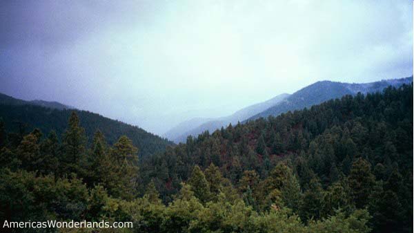
July and August are the rainy months and it can come down hard, especially up high (I have first hand knowledge of this). Stay off high ground in storms due to lightning hazards. There's plenty of burned trees along the ridges to warn of lightning dangers.
Flies can be a bother in the fall according to the rangers. Long sleeves, pants and bug spray will help.
Animals in the area include black bear, mountain lion, mexican gray wolf and blacktail rattlesnake. I was bounding down an incline at Jordan Spring when I was suddenly greeted by a rattlesnake. Ask the rangers if you're unsure of what to do when encountering any of these animals.
An amoeba which can enter through the mouth or nose has been found in area hot springs and can cause meningitis. Don't submerge your head or splash water on your face.
Camp sites are located in various areas throughout the National Forest. You might want to consult a map of the area or stop at a ranger station (Truth or Consequences, Silver City, Glenwood, Cliff Dwellings Visitor Center, etc.) to select a site. Camping is available in the area of the cliff dwellings at two sites (paved lot, running water). Primitive camping is also available in the area not far up the road toward Silver City from the visitor center. A privately owned RV park is also nearby and just a little farther up the road from the primitive camping area.
Lodging and dining can be found in Silver City and a number of places in the surrounding communities. Some of the small area towns would love to have you stay at the small bed and breakfasts.
Maps
Maps are available for all three wilderness areas as well as the Gila National Forest. These maps can be purchased at visitor centers in Truth or Consequences, Silver City, Glenwood, Mimbres the Cliff Dwellings Visitor Center and others in the area. Maps can also be ordered from the USDA Forest Service web site.
An online topographic map of the Gila Cliff Dwelling area is available here.
Follow this link for the Hillsboro and Sawyer Peaks online topographic map.
More information including ranger station phone numbers can be found on the USDA Gila National Forest web site.
I found both of these books to be informative and used them to plan my various hikes. I wouldn't have done nearly as much hiking without them and still have several pages dog-eared for future adventures. I had trouble finding information about the hikes in the area so used these books extensively when planning my trips. The rangers in each of the surrounding communities were helpful; but some didn't do much hiking and most only knew about their immediate vicinity. If you're looking for something more comprehensive to help you plan, these are your choices.
(click the picture to buy from Amazon.com) Note: Prior Cabin appears in the wrong place in the Falcon Guide on the map on p 240. It's actually nearer the junction of the Prior Creek, Woodland Park and Chicken Coop Canyon Trails (watch for this where Prior Cabin might be shown on other pages). Otherwise, it includes a wealth of trail information. |
|
 |
Rangers at the Gila Visitors Center told me this
book was coming; but I had yet to see it available anywhere until now. I
don't own this book (yet); so can't speak directly to its content.
However, I am excited to see that it's available and will be purchasing this
book prior to my next visit. This is one of the least known areas and
nobody I asked knew anything about it except for the Hillsboro Peak hike
mentioned above. This book will be a must-have purchase for me when
I go back. Click the picture to buy it from Amazon.com. |
 |
Hiking Ruins Seldom Seen. A site visitor purchased
this book. Reviews are excellent and it sounds interesting. Click the picture to buy it from Amazon.com. |
 |
Travel narrative similar in many ways to Desert Solitaire by Edward Abbey. Tells about the author's experience spending several days traveling through the Gila Wilderness. It's an enjoyable read especially if you're familiar with the area. Click the picture to buy it from Amazon.com.
|
 |
I bought this book after becoming familiar with Leopold's work in establishing the Gila as the first wilderness area in America. I'm sorry to say that I still haven't read it; but I take it with me on trips in hopes of doing so.
Click the picture to buy it from Amazon.com. |
 |
Just for fun...
A Walk In the Woods by Bill Bryson is laugh-out-loud funny. It's a story of writer Bill Bryson and buddy Katz trying to tackle the Appalachian Trail without as much as a weekend trip to their credit. Bryson is hilarious and the likeable Katz gives Bryson some good material. I have loaned this book to several friends and purchased multiple copies as gifts. Hikers and non-hikers alike will appreciate the humor as well as Bryson's observations. I was reading this on an airplane once when I hit a funny part and started laughing out loud. I couldn't stop laughing and ended up sharing the passage with my fellow passengers to their delight. |

click the graphic to bring up all books from Amazon.com on hiking in New Mexico
Thank you for visiting.
Did you find this information helpful?
Disclaimer: information provided in good faith with no warranty or obligation attached. Be prepared for your adventures.
Your safety is your responsibility. Explore with respect.
America's Wonderlands
Copyright 2002 K. Venator