|
|
Welcome to the America's Wonderlands guide to exploring Zion National Park. Content is divided into the following sections as described by their respective headings: Logistics and Travel Information, Hiking Trails, Advisories & Suggestions as well as a special section on hiking The Narrows (Zion National Park's famous hike recognized as one of America's Top 100 Adventures by National Geographic). Check out the Canyon Country gallery to see lots of great Zion National Park pictures.
Logistics & Travel Information
Zion National Park is approximately 160 miles northeast of Las Vegas, Nevada in southwest Utah. Map of Zion National Park vicinity. Directions from the Las Vegas Intl airport to Zion.


Las Vegas is probably the most convenient and
affordable access point to Zion. Travel to Zion without going
through Las Vegas is possible; but will likely involve an extended trip. Travel to the east and south
of Zion is limited by Lake Powell, the Grand Canyon and
Canyonlands. Travel south of Zion is possible only by going around the Grand Canyon via Las
Vegas or Page, AZ (near Lake Powell's Glen Canyon Dam).
Most visitors to the area tend to split their time between Zion and Bryce Canyon National Park. Interest and activity level can help you decide how much time to spend in each park. Bryce Canyon offers easy access to beautiful views along the scenic drive while the best features of Zion are found along hiking trails. As a result, those who don't do as much hiking will tend to like Bryce Canyon better. Those who enjoy hiking and climbing will tend to like Zion better. Both parks are definitely worth the trip.
Visitors to Zion National Park and/or Bryce Canyon National Park may also want to include stops at the Grand Canyon north rim & Cedar Breaks. Other stops might include Escalante, UT and Page, AZ.
Camping is available inside Zion National Park and at private campgrounds in the area. Sites in the park's Watchman campground can be reserved in advance using the National Park Service's online reservation system. The campgrounds often fill up on busy weekends.
Rooms are available for rent just outside Zion's south entrance in Springdale, UT. You'll also have to go into Springdale for a shower if you're camping. The Zion Lodge offers accommodations inside the park boundary.
A shuttle bus provides visitor transportation throughout the park from April thru late October. Passenger vehicles are not allowed into Zion Canyon past Zion-Mt. Carmel Highway when the shuttles are running. The shuttles run frequently and stop at all points of interest in the park.
Permits are required to spend the night in the backcountry (incl. The Narrows). Call the backcountry office at 435.772.0170 with questions about permits.
To reserve a campsite using the National Park Service's online reservation system click here.
To reach the National Park Service Zion National Park page, click here.
To find out more about lodging, shopping and dining in Springdale, click here.
To view a sample backpacking checklist, click here.
Zion National Park Hiking Trails
Hiking the Narrows - Spectacular adventure! More on backpacking or day hiking The Narrows below.
Hiking Observation Point - The view from Observation Point is amazing. It's a difficult, 8 mile round trip (out & back) with a combined elevation change of 4200 feet (2100 up, 2100 down). Look down on Angel's Landing from up here (photo). Park at the Weeping Rock trailhead parking area.
Weeping Rock - Park here for the Hidden Canyon and Observation Point hikes. The Weeping Rock is an interesting destination in it's own right and is a short easy hike from the parking area.
Hidden Canyon - Moderate, 2 mile round trip to the mouth of the canyon. It's as hard as you want to make it from here. There's really no goal to this hike except to go until you have to turn around. The best part about this hike is figuring out how to get past the progressively more difficult obstacles. For example, after successfully completing each challenge, my hiking buddy and I were sure that we had gone farther than anyone else. We kept encouraging each other... "oh, let's go one more". Each time, "dang! there's another footprint"... so we 'had' to keep going. We eventually got to a point where one of us had to stay behind and provide a foothold so the other could climb up a rock wall. We took turns climbing up top and looking around but this was the end of the road for us. More advance, non-technical climbers might have been able to go a bit farther (a rope would have helped). It got pretty treacherous. Be sure to hike with a buddy in case you have trouble with one of the obstacles. Park at the Weeping Rock trailhead. (photo)
Angel's Landing - those afraid of heights should not attempt this hike. Difficult, 5 mile round trip with a combined elevation gain/loss of 3000 feet. Amazing views, dramatic drops on both sides. (photo)
Subway - deep water, slot canyon adventure. A special permit is required can be requested via fax or through the Zion National Park web site. Requests should include 3 prioritized dates for the trip. Trip dates awarded by lottery. Requests are accepted in January for trips in April, February for trips in May, etc). Permits can be picked up the day before the hike or by 10am the morning of the hike. Fifty feet of webbing is required. If you don't have webbing, you can most likely get it at a shop in Springdale. Call the backcountry office for more info (435.772.0170)
Canyon Overlook - Easy, 1 mile round trip hike to fantastic views of the canyon. Access via parking area at Zion's east entrance.
Kolob Canyons (Kolob Arch) - Moderate, 14 mile round trip to one of the largest arches in the world. To reach the Kolob Canyons area you have to drive south, out of Zion and north on highway 15. Check your map for the most direct route.
Be sure to check out a map of the area and talk with staff at the visitor center to find out about other trails and activities.
Hikers should pay close attention to the weather. Slot canyons can flood without warning during storms. Storms are especially likely in July and August.Zion can be hot in the summer. Temperatures of 100F or above are not unusual. Bryce Canyon is at a higher elevation (around 3000' higher) and is cooler. Overnight lows in Bryce, even in summer, can reach 40. Camp sites at Bryce Canyon are available on a first-come, first-served basis. Arrive early.
If you plan to camp in Zion, reservations are recommended. If you don't have a reservation, arrive early. Arriving late on a weekend is not a good idea without a reserved site.
Use a robust walking stick if you plan to hike the narrows. Wear appropriate shoes.
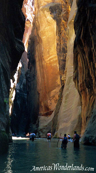
Hiking the Narrows of Zion National Park is fifth on National Geographic's list of Top 100 American Adventures. The through hike is a 16 mile trek along the Virgin River where at the extreme, cliff walls rise nearly 2000 feet and are only 30 feet apart. Much of the hike is in the water. Proper footwear is a must and a robust walking stick is an absolute necessity. Visitors planning to hike The Narrows from the top down should plan to shuttle themselves to the trailhead or plan to reserve space on the shuttle operated by the Zion Lodge. This service is independent of the park shuttle and provides transportation to the trailhead on private property (Chamberlain's Ranch). You may be able to shuttle yourselves using 2 cars; but you'll want to verify that road conditions are suitable for your vehicle. The Zion Backcountry office should be able to advise you on this. Give yourself an hour and a half to reach the trailhead. Permits are required for through hikes and overnight trips and can be picked up the day before the hike on a first-come, first-served basis. Camping permits are limited and go fast so get there early. Camp sites can accommodate anywhere from 2 to 12 people depending on which one is available (most can hold 4-6). You may also be able to get a permit the day of the hike if you get there when the office opens. The tricky part is getting a camping permit for the same day as your shuttle ticket. If the shuttle is full, you may be able to find another group and shuttle each other. Plan to finish in time to catch the park shuttle at the Temple of Sinawava. The shuttle will take you back to the Visitor Center where you most likely left your car the day before. The best times to hike the Narrows is in June and September. Trips through the Narrows from November thru May require wet suits and cold weather gear. Thunderstorms are likely during July and August.
A Backcountry Planner can be obtained by calling the backcountry office. It will provide additional information about hiking the Narrows and other areas.
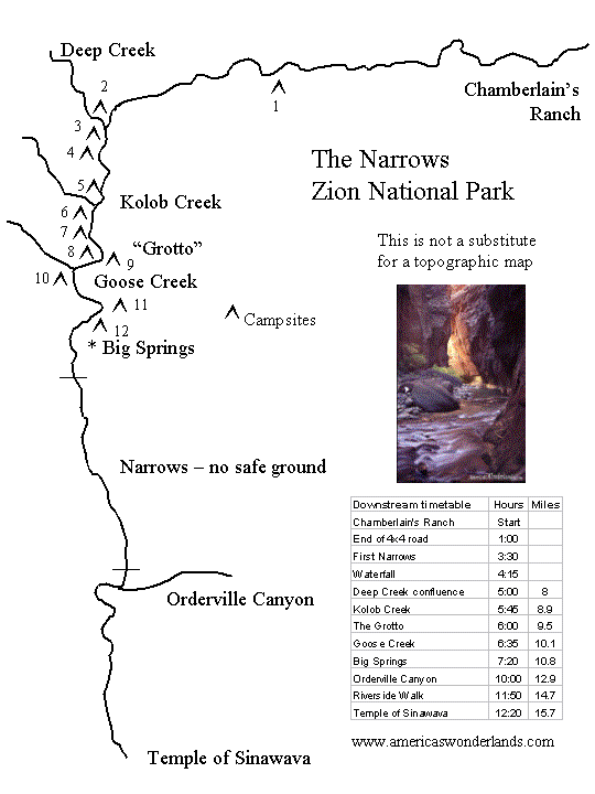
Hiking The Narrows: timetable and map
|
Map & Timetable (click to enlarge)
|
If hiking upstream, allow 4-5 hours to reach Orderville Canyon (start of the narrows proper) plus whatever time you would like to explore Orderville and continue up the Narrows. Be sure to allow enough time for your return trip.
Gear including shoes, walking sticks, neoprene socks and dry suits can be rented or purchased in Springdale.
Directions to Chamberlain's Ranch (check locally to verify conditions): drive 2 1/2 miles east on Rt 9 from the park's east entrance. Turn left onto a paved road (North Fork Road) and continue 18 miles to a bridge that crosses the North Fork of the Virgin River. Turn left beyond the bridge and drive 1/4 mile to the gate of Chamberlain's Ranch (be sure to close the gate behind you). Drive 1/2 mile further and park just before the road crosses the river. To begin the hike, cross the river and follow the road for approx. 3 miles at which point you'll enter the river.
Buying from our sponsors helps support the site.
If you choose to buy later, please return and click through. Thanks!
|
|
I used the 2nd edition of Frommer's Zion and
Bryce Canyon National Parks by Don and Barbara Laine to plan my
first trip to Zion and Bryce and found it very useful to take along on
subsequent trips. It's a good all-around reference for people with
varying interests. It includes information on travel, lodging,
camping, dining and activities including descriptions of hiking
trails. The book also highlights recommended areas and includes
lists of category "bests" (e.g. Best Scenic Areas, Best
Backcountry Hikes etc.). I tend to like this type of organization
because it helps to build a short list of options without reading a lot.
Links take you to the 3rd and most recent edition of this book (as of
5/27/2002).
Hiking Zion & Bryce Canyon National Parks (A Falcon Guide) is more suited for selecting hiking trails in the parks. This book includes much more information about hiking (incl. backcountry trips); but not so much in the way of general information. Great reference for planning hiking adventures. Just for fun... Desert Solitaire by Edward Abbey was originally published in 1968. Abbey served as a park ranger in Arches National Park and writes about his experiences throughout the desert southwest. This work is very popular in the region and nearly everyone knows of Abbey. This is not a travel guide; but simply one man's expression of his love for the country. A Walk In the Woods by Bill Bryson is laugh-out-loud funny. It's a story of writer Bill Bryson and buddy Katz trying to tackle the Appalachian Trail without as much as a weekend trip to their credit. Bryson is hilarious and the likeable Katz gives Bryson some good material. I have loaned this book to several friends and purchased multiple copies as gifts. Hikers and non-hikers alike will appreciate the humor as well as Bryson's observations. I was reading this on an airplane once when I hit a funny part and started laughing out loud. I couldn't stop laughing and ended up sharing the passage with my fellow passengers to their delight. Click the picture of the book you'd like to buy from Amazon.com.
click the graphic to bring up all books from Amazon.com on Zion and Bryce Canyon National Parks |
Exploring the Backcountry of Zion National Park: Off Trail Routes by Thomas Brereton and James Dunaway. Zion Natural History Association, 1996. This small (89 pages); but interesting book includes descriptions of 12 hikes with a nice section on The Narrows. Some of the hikes described here require rappelling.
Zion and Bryce Canyon topographic maps available from Trails Illustrated. Online topographic maps area also available. Follow the link and navigate around to view your area of preference (online map).
|
Other Sources
|

Enjoy your trip!
Did you find this information helpful? Do you have corrections?
If so, please send feedback to the author.
Disclaimer: information provided in good faith with no warranty or obligation attached. Be prepared for your adventures.
Your safety is your responsibility. Explore with respect.
AmericasWonderlands.com
Copyright 2002 K. Venator